- Mobile Phone Chargers[10]
- Other Electronic Measuring Instruments[10]
- Other Measuring & Analysing Instruments[10]
- Navigation & GPS[10]
- Satellite TV Receiver[1]
- Other Electrical Instruments[2]
- Other Hand Tools[1]
- Measuring Tools[3]
- Level Measuring Instruments[4]
- Theodolites[8]
- Other Measuring & Gauging Tools[10]
- Other Analysis Instruments[3]
- Forestry Machinery[1]
- Gauges[2]
- Hand Tool Sets[1]
- Laser Rangefinders[2]
- Multi-Functional Beauty Equipment[1]
- MIG Welders[4]
- Arc Welders[3]
- Other Welding Equipment[4]
- Integrated Circuits[10]
- Other Electronic Components[1]
- Testing Equipment[10]
- Switching Power Supply[8]
- Other Police & Military Supplies[5]
- Compasses[1]
- Compasses[3]
- Heat Pump Water Heater Parts[1]
- Electric Water Heaters[10]
- Data Processing[1]
- Contact Person : Ms. Woo Lisa
- Company Name : Shenzhen Pengjin Technology Co., Ltd.
- Tel : 86-755-83322229
- Fax : 86-755-25121578
- Address : Guangdong,SHENZHEN,ROOM B3, FLOOR 4TH, JIALE BUILDING, YANNAN ROAD, FUTIAN, SHENZHEN
- Country/Region : China
- Zip : 518018
Hi-Target Q6 COOL handheld GPS,data collecting
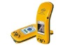
Hi-Target Q6 COOL handheld GPS,data collecting
Q Cool GIS WORLD IN HANDHigh-Class System ConfigurationWINCE5.0 System530MHz High Speed ARM920T Processor128M Large Capacity Storage Memory3.5 Inch Expert Outdoor Color Touch ScreenProfessional GPS FunctionalityAdopt International High Precision Surveying GPS MainboardInternal High Sensitivity Interference Resistant GPS AntennaAccuracy: Single Positioning: 2.5MSBAS: 1MReal Time Difference: 0.3MPost-Processing Difference: 0.3MStatic Survey: ±5mm+1ppmConvenient Wireless CommunicationInternal GPRS communication module, achieving GPRS long distance data transmissionInternal Bluetooth, for convenient wireless data transmissionWith Bluetooth technology, wireless connects to range finder and Beaconing instrument fordata collectingVisible Data ImageInternal high definition camera, able to add image attribute information for collecting on siteAutomatically match GPS coordinates and image attribute informationInternal microphone, use real time voice information for marking AttributeMature Reference Station TechnologyProvide comprehensive reference station solution, including HD-CORS, single reference station and post-difference base station.Powerful reference station monitor management software, for real time monitoring GIS mobile terminal.Real time information mutual transmission between monitor center and Mobile terminal by GPRS communication.Comprehensive Software SolutionHi-Q Data Collection SoftwareGraphical software interface, easy to learn and simple operationConvenient data dictionary edition functionality, for inputting elements and kinds of attributes in advance, and for field real time edition.Provide various position data and attribute information collection methods, such as manual collection, automatic collection, public point collection, offset collection, manual inputting and menu selection.Input image and vector graph in various formatConvenient calculation on length, distance and area.Able to real time update data to server software on site, achieve real time management by monitoring centerProvide various work modes for your selection: SBAS, real time difference, post processing and static survey ect.Mutual international coordinates system conversionHi-Q Tools Desk-Top Processing SoftwareMore efficient data dictionary establishing and editing functionGraphic scan function for large volume vector, supporting basic graphic operationProviding powerful graphic image data matching and pretreatment functionData convert port, supporting multi-format including: shp, mif, dxf, txt and csvGPS post-processing software with powerful functionality, Solving static and post-difference data.Q Cool ApplicationsCadastre Survey, Line Inspection, Forest Survey, Environment Protection, Resource Management, Hydrograph Survey, Traffic Monitoring, Catastrophe Prevention ect.Features and Specification
| Feature | Item | Specification | |||
| Receiver | Signal Receiving | 14 channels L1 + carrier phase receiver, able to receive SBAS satellite signal. | |||
| Accuracy | Q1 | Single position: SBAS: <1~ | |||
| Q5 | Real time difference: Post processing difference: (<)SBAS:(1δ)S ingle position:(3δ)Static: ±+1PPM(Need external antenna) | ||||
| Q6 | Real time difference: Post processing difference: (<)SBAS:(1δ) Single position:(3δ)Static: ±+1PPM(Need external antenna) | ||||
| Q-RTK | Single Frequency RTK: 3~SBAS:(1δ)Single position:(3δ) Static: ±+1PPM(Need external antenna) | ||||
| GPS Antenna | Internal high sensitivity GPS single frequency (L1) antenna, external antenna port, available to connect external high-gain antenna with automatical switch ability | ||||
| Core | Main Frequency | 530 MHZ high-speed ARM 920T | |||
| Operation System | WINCE5.0 operation system | ||||
| Screen | 3.5 inch, 320 X 240 pixel, TFT 262K color "Sharp" touch screen, high definitionunder sunshine. | ||||
| Data Storage | SDRAM:128MBFLASH:512MB card slot: awailable for TF card in large storage size | ||||
| Data Transmission | Embedded GPRS communication module and Bluetooth communication function | ||||
| Camera/Microphone | 1.3 million pixel camera in high definition/built-in microphone records sound | ||||
| One USB port, one Bluetooth port and one RS232 port. Available to connect external instruments including laser range finder, beacon and radio through Bluetooth and cable connection. | |||||
| Voltage | Lithium battery 7.6V, 2000mAh | Working Environ-ment | Temperature | ~ | |
| Time | 6 hours | Waterproof | Ip67 | ||
| Charge Mode | Support online charging | Shock-Resistant | Bear natural drop | ||
| Size | 22cmx9cmx | Weight | 0.7kg | ||
Hi-Target Q6 COOL handheld GPS,data collecting